CHAPTER 5
Zoning, Subdivision and Annexation
| Harlingen's Vision 2020 Comprehensive Plan is a
guide for use by City officials, administrative staff, and citizens in making decisions
that shape the future growth and development of the community. Comprehensive planning is a
continuous process of articulating a broad set of interrelated goals and objectives for
the City, establishing policies and procedures, and formulating detailed programs of
action for achieving those goals and objectives. In order to carry out the resulting
plans, the City utilizes a variety of implementation tools, including zoning, subdivision
regulations, and annexation. This chapter of the Vision 2020 Plan focuses on the City of
Harlingen's Zoning Code, Subdivision Ordinance, and Annexation process, in order to review
the existing policies and procedures, and to provide recommendations for utilization of
these important plan implementation tools. Review of Existing Ordinances The City of Harlingen's existing zoning code, subdivision regulations, and annexation procedures were reviewed during the development of the original comprehensive plan adopted in 1996. The Zoning and Subdivision ordinances were reviewed for compatibility with State enabling legislation and court decisions pertaining to relevant cases. Procedures of the Planning and Zoning Commission for zoning and subdivision processing were also reviewed. This review included analyses performed by the City staff and consultant, as well as review by the Vision 2020 Steering Committee. The Steering Committee established an Ordinances Review Subcommittee, which assisted the City staff and consultant in reviewing the existing ordinances. Several subcommittee meetings were conducted to review and discuss the existing ordinances, and to identify potential options for improving the ordinances. City staff also conducted an administrative review of the zoning and subdivision ordinances, which identified needed changes and revisions. Based on the recommendations provided by the Ordinances Review Subcommittee and City staff, suggested revisions to the existing ordinances were drafted and submitted for review and consideration by the Planning and Zoning Commission and City Commission. In 1997, the City Commission adopted a revised Zoning Ordinance. During the 2000 plan update, the Subdivision Ordinance was completely revamped to better communicate subdivision requirements and guidelines and is pending adoption by the City Commission. Zoning, subdivision and annexation are summarized in the following sections. Ordinances are available at the City of Harlingen Planning and Development Department. Zoning Ordinance The City of Harlingen Zoning Ordinance creates zoning districts or classifications and defines the types of land uses that are permitted within each district. The Zoning Map illustrates how property in the City is classified according to the various zoning districts. The Zoning Ordinance applies only to land within the corporate limits of the City. The text of the Zoning Ordinance explains the zoning rules that apply to each district. The zoning districts are defined within the text, including the types of land uses that are permitted by right within each district, uses that are prohibited, and other specific uses that may or may not be permitted depending upon the fit between the proposed use and the place for which it is proposed. In addition to defining the uses permitted within districts, the Zoning Ordinance also establishes regulations governing minimum lot area, lot width and depth, height of buildings, required front, side and rear yards and setbacks, accessory uses and off-street parking and loading. The Zoning Ordinance also addresses special uses and districts such as sexually oriented businesses, planned development districts, La Placita Overlay District regulations and nonconforming uses. The ordinance defines the roles and responsibilities of the City Commission, Planning and Zoning Commission, Zoning Board of Adjustment and City staff responsible for the administration and enforcement of the ordinance. Subdivision Regulations Besides zoning regulations, Subdivision Regulations are equally instrumental in shaping future development of the City. Their purposes are broad and include the following objectives:
The Subdivision Regulations govern the conversion of raw land into buildable lots and parcels. They apply to land within the corporate limits and also to the extraterritorial jurisdiction (ETJ) of the City. Because Cameron County is a county along the Mexican border, Harlingen's ETJ for subdivision regulation purposes extends five (5) miles beyond the City limits, except where reduced by agreement with another municipality with an overlapping ETJ area. The Subdivision Regulations establish requirements for public improvements, specify minimum standards for land development, and prescribe the procedures for submittal, review and approval of subdivision plats. Enforcement of the subdivision regulations occurs through the plat review and approval procedures, which enable the City to ensure that new subdivisions are developed to established standards. Annexation Annexation is the process by which the City extends its municipal services, regulations, voting privileges, and taxing authority to new territory. The City annexes territory to provide municipal services to developed and developing areas, and to exercise regulatory authority necessary to protect public health, safety and general welfare. Annexation is also a means of ensuring that residents and businesses outside the City's corporate limits, who benefit from access to the Harlingen's facilities and services, share the tax burden associated with constructing and maintaining those facilities and services. Annexation and the imposition of land development regulations may also be used as a growth management tool to implement the comprehensive plan.Annexation extends the City's ETJ, enabling the City to regulate the subdivision and development of land over an expanded area. Annexation authority extends into the ETJ of the City, which is the area outside the corporate limits but within a certain distance of the corporate limits. The City of Harlingen's ETJ for annexation purposes extends two (2) miles beyond the City Limits but will increase to three and one half (3 �) miles if the 2000 diennial census indicates Harlingen's population above 50,000 persons. The City of Harlingen, as a Home-Rule City, has authority under Texas annexation law to annex territory on a non-consensual basis. However, in annexing property there are stringent procedural and service requirements that must be met by the City relative to the State of Texas enabling legislature that took effect September 15, 1999. The City must prepare a three-year annexation plan that specifically identifies annexations that may occur beginning on the third anniversary of the date the annexation plan is adopted. The City must compile a comprehensive inventory of services and facilities provided by public and private entities in each area proposed for annexation. The inventory must be available to the public for inspection. Before the first day of the 10th month after the month in which the inventory is prepared, the City must complete a service plan that provides for the extension of full municipal services to the area to be annexed. The service plan must provide for the extension of basic fire, police, and solid waste services within sixty (60) days of annexation and for maintenance of water, sewer, streets, street lights, parks and recreation facilities, and other public facilities serving the proposed annexation area. If the annexed area had a lower level of services, infrastructure and infrastructure maintenance than the level of service provided within the City before annexation a service plan must provide the annexed area with a level of services, infrastructure and infrastructure maintenance that is comparable to the level in other similar parts of the City. If the annexed area had equal services, a service plan must maintain the same level of services. If the annexed area had a superior level of services, a service plan must provide the annexed area with a level of services that is comparable to the level of services available in other parts of the City. Construction of capital improvements required for extension of municipal services must begin within two and one-half (2 �) years of the annexation and be completed within four and one-half (4 �) years. These requirements may not apply if the annexation is initiated by the landowners to be annexed and the City and owners agree that the improvements will not be completed within four and one-half (4 �) years. The geographical size of areas annexed in any given year is limited to a total area equal to ten percent (10%) of the City's existing incorporated area. The amount of land that can be annexed in a given year is cumulative, so that if the City does not annex ten percent (10%) of its existing area one year, it may carry forward that acreage and combine it with another ten percent the next year. If the City is carrying over an allocation, it may not annex in a calendar year a total area greater than 30 percent of the incorporated area of the City as of January 1st of that year. An annexation area must be contiguous to the existing City Limits and must be at least 1,000 feet in width at its narrowest point. The City may preclude the incorporation of a new municipality within its ETJ.Other annexations may take place, without being on the three-year plan, for areas that qualify under the exemptions set out by state law. The most notable of the exemptions are areas containing fewer than 100 separate tracts of land on which one or more residential dwellings are located, areas subject to non-annexation contracts through an industrial district agreement, areas in which a majority of the property owners request annexation or areas located in economically distressed subdivisions commonly called 'colonias'. Annexations completed outside the three-year plan have different hearing and notification requirements than set forth in this section. Annexation Hearing Requirements Before the City may institute annexation proceedings, the City must conduct two public hearings at which persons interested in the annexation are given the opportunity to be heard. The hearings must be conducted not later than the 90th day after the date the inventory of services and facilities is completed. The City is required to post notice of the required public hearings on its Internet website, as well as, in a local newspaper. Annexation Policy A clear policy for guiding future annexations will help to minimize the future costs of providing municipal facilities and services in newly annexed areas, and to reduce the complexity of the State of Texas enabling legislature on annexation procedures that took effect on September 15, 1999. The Annexation Policy should include the following:
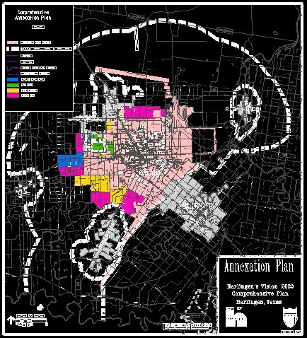
Future annexations for the City of Harlingen should encompass growth areas as future development occurs, in order to extend the City's ability to effectively guide and manage land development, to provide for orderly and cost-effective improvement and extension of public infrastructure and services, and to expand the City's tax base in coordination with the increasing demands for municipal facilities and services. Annexation should also be utilized for extending the City's jurisdiction to encompass critical areas and facilities in order to manage and protect adjacent development areas. Strategies for planning future annexation generally include two recommended approaches to delineating potential annexation areas. One strategy is to annex urbanizing areas adjacent to the City that are either already developed or are anticipated to become urbanized in the near future, with the goal of expanding the City's jurisdiction, service area, and tax base consistent with continuing growth and development. The second strategy is commonly referred to as "strip annexation" to expand the City in linear corridors with the objective of extending the City's ETJ. The State of Texas' annexation enabling legislation is designed to discourage strip annexations by limiting the minimum width of annexation areas to 1,000 feet, requiring contiguity with the existing incorporated area, and prohibiting annexations that would result in "donut"-shaped areas of unincorporated land surrounded by newly annexed area. The recommended plan for future annexations by the City of Harlingen is shown in Figure 5-1. The annexation plan is a general plan for guiding the expansion of the City in future years. Potential annexation areas are shown for three time intervals, including one to five years, six to ten years, and 11 to 20 years. The generalized extent of areas that are likely to be considered for annexation during each time interval are identified. The actual location and boundary of annexation areas may vary and the inclusion of areas in the annexation plan does not represent a commitment of whether areas will actually be annexed or any specific time schedule for potential annexations. The potential future annexation areas were identified based upon the future land use plan and anticipated stages of continuing development for five, ten and 20 year timeframes. The City's Planning and Development Department should conduct annexation studies on an annual basis to evaluate and consider potential annexations conforming to the three-year timeframe. Specific areas recommended for consideration should be identified and assessed in accordance with the objectives, policies, strategies and annexation plan which are contained in this Vision 2020 Comprehensive Plan. Additional information about the City's Zoning Ordinance, Subdivision Regulations, and Annexation is available from the City of Harlingen Planning and Development Department. Goals and Objectives A majority of the goals and objectives for the Zoning and Subdivision ordinances listed in the original comprehensive plan have been accomplished with the substantial revisions of the subdivision and zoning ordinances. The few goals and objectives that were not are included below with recommended maintenance by City staff. The following actions are recommended:
|
Planning & Development | Harlingen's Vision 2020 Comprehensive Plan | Table of Contents
(c) copyright 2004, City of Harlingen